The Salish Sea is particularly rich in biodiversity, due to a combination of shelter from extreme storms and strong natural upwelling. The coastal ecosystems of this region support a large number of species, many of which are now at risk due to encroaching urban development, high marine traffic, and exploitation. Galiano Island sits in the heart of this region, between Vancouver Island and the Vancouver mainland. We are surrounded by three Rockfish Conservation Areas, two Important Bird Areas (IBAs), and are a hub for boater and tourist activity. Learn more about the Active Pass IBA.
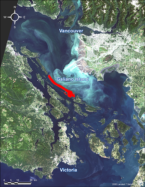
Satellite image showing the location of Galiano Island (red)
Fostering Marine Stewardship for Positive Change
At the Galiano Conservancy, we are providing research and raising awareness for the many species that use this marine environment through public outreach and our environmental education programs. We are working as part of the Southern Strait of Georgia Marine Conservation Network for the establishment of a National Marine Conservation Area (NMCA), which will provide protection of critical habitat for species at risk and conscientious management of these coastal ecosystems from seafloor to seashore. At the Galiano Conservancy we have recently focused on rockfish research, and are raising awareness about the Rockfish Conservation Areas in our region to promote their recovery from overfishing.
Rockfish Recovery and Conservation
Many of us know rockfish as “Red Snapper” or “Rock cod’, as we may see them in the fish market. In truth, we have at least 38 species of rockfish in BC waters, and about one third of those once dwelled in the Salish Sea. Since the late 1990s, several species of rockfish have shown considerable declines due largely to overfishing. In 2007, the Canadian government implemented 164 Rockfish Conservation Areas (RCAs) in an attempt to recover rockfish populations; however, work done by the Galiano Conservancy Association and others is showing that rockfish abundance around Galiano and throughout the Salish Sea remains low. We still have reason to believe that rockfish from each species remain in our waters, and that given the opportunity, their populations can recover from overfishing.
Current Project: Rockfish Outreach and Education in the Gulf Islands
Partnering with Valdes Island Conservancy, we are undertaking a multi-year project (2014-2016) aimed at public outreach and education as well as population surveying around Galiano and Valdes Islands. Collaborators include students and researchers from University of Victoria School of Environmental Studies, Vancouver Aquarium, Outershores Expeditions, Rockfish Divers, Marine Life Sanctuary Society of BC, Department of Fisheries and Oceans, and the Lyackson First Nation.
Outreach Materials:
Island Tides Insert: Rockfish News
Rockfish Conservation Area (RCA) Maps: Regional Map in letter size or 2×3 ft. Local Gailano Map in letter size or 2×3 ft. Local Valdes Map in letter size or 2×3 ft.
(Note: These materials are for wide distribution and use. We would be happy for you to print your own copy or post on your website, so long as the Galiano Conservancy Association and Valdes Island Conservancy are acknowledged as the producers of the materials, and the materials are not altered in any way. Please contact us with questions.)
Past work at the Galiano Conservancy
In 2012 the Galiano Conservancy Association completed the Freedom to Swim: Research Portion for the Rockfish Recovery Project, sponsored primarily by Mountain Equipment Co-op, during which we discovered that there are rockfish both inside and outside RCAs around Galiano, but not as many as there should be, and only representing a few of the species that we hoped to see in the area.
Rockfish Research in the School of Environmental Studies at University of Victoria
Darienne Lancaster, a Master’s Candidate in the School of Environmental Studies at the University of Victoria is also conducting research on the Rockfish Conservation Areas (RCAs) in the Southern Gulf Islands. This summer she will be stopping by Galiano Island on her Gulf Island tour to run interviews and monitor fishing effort in local RCAs. These interviews with recreational fishers and visual monitoring of RCAs will be used to assess levels of recreational fishing effort in RCAs. The project will also investigate fishers’ perceptions of the RCAs, general knowledge of rockfish conservation, and ask how conservation could potentially be improved. Based off of these results, Darienne will also likely be conducting underwater surveys of rockfish populations in areas of high and low fishing effort to determine the effect of fishing on rockfish populations. If you see Darienne working on Galiano this summer stop by and say hello and fill out a survey if you have a chance!
What can you do to help?
- Contact Jenna to get involved in our current Rockfish Conservation Project funded by the federal Habitat Stewardship Program – we’ll be doing public outreach, workshops, water access signage and dive surveys to monitor the local populations around Galiano and Valdes Islands
- Get involved in R.E.E.F. community citizen science dive surveys as a diver, boat tender, or outreach volunteer. Learn to ID fish in their fun and interactive “Fishinars” (webinars).
- Join the Vancouver Aquarium’s annual community rockfish surveys
- Learn more about scientific diving through Rockfish Divers, and come to Galiano to try out your skills!
- Join Project AWARE and become dive buddies with our biologist, Lia
- Support the implementation of a proposed 140,000 hectare National Marine Conservation Area (NMCA) in the Southern Strait of Georgia
- Find out more about rockfish and spread the word about Rockfish Conservation Areas, fishing closures in your area, research that is being done, sustainable fisheries and how rockfish fit into the food industry, and tips for fishermen to avoid killing unwanted rockfish