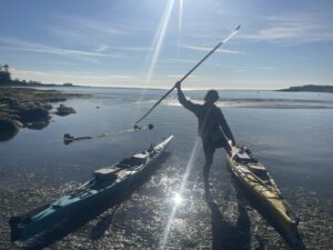
Amelia Marshall at Cain Beach by Marina Cousins
Bull kelp (Nereocystis luetkeana) is one of the foundational species of British Columbia’s coastal waters. Bull kelp forms underwater forests that provide critical habitat for juvenile fish, invertebrates, and other marine organisms, while also offering shelter, food, and nursery habitat for species throughout their life cycles. Kelp forests help support biodiversity, contribute to coastal productivity, and play an important role in maintaining healthy marine ecosystems.
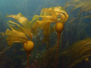
Bull kelp (Nereocystis_luetkeana), Wikimedia Commons
On July 29, I had the opportunity to participate in a bull kelp monitoring survey alongside two members of the Mayne Island Conservancy, (Rob Underhill and Ethan Heckrodt), who guided us through the process. It was an eye-opening experience that gave me a much deeper appreciation for the fieldwork involved in monitoring these important marine habitats.
Our morning began at Georgeson Bay, where timing was everything. We met from 9:30 a.m. to 12:30 p.m. carefully planning our survey to coincide with the lowest tide and slack current—the ideal conditions for monitoring bull kelp from the water’s surface. These calm conditions reduce water movement, improve underwater visibility, and make it much easier to accurately identify and map kelp beds.
After arriving at the beach access, we carried the kayaks down a steep staircase to the shoreline before preparing them for the survey. Each kayak was outfitted with the equipment needed for both safety and data collection, including spare paddles, hand pumps, tow ropes, a buoy, life jackets, clipboards, data sheets, and handheld GPS units. Seeing the amount of preparation required before we entered the water highlighted how carefully organized monitoring surveys must be to ensure both participant safety and reliable data collection.
Before launching, Rob introduced us to the monitoring methodology and explained how bull kelp beds are classified. Individual patches are mapped as points, lines, or polygons depending on their size, density, and distribution. An eight-metre spacing threshold is used to determine whether nearby kelp plants are considered part of the same bed or separate groupings.
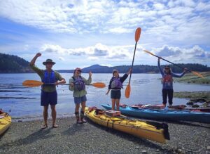
Ethan, Amelia, Marina, and Millie Orientation Georgeson Bay by Rob Underhill
Learning these classifications helped me understand that mapping kelp involves much more than simply noting where it grows; consistency in how beds are identified ensures that surveys completed over multiple years can be accurately compared to detect changes.
Once our orientation was complete, we paddled into Georgeson Bay, which is located across from Mayne Island in Active Pass. Throughout the survey we monitored approximately four distinct groupings of bull kelp.
The conditions that day were ideal for kayaking. The sky was clear and blue and the low tide provided exceptional underwater visibility. Looking down through the water, it was easy to appreciate the complexity of the marine environment hidden below the surface.
Curious harbour seals regularly surfaced beside our kayaks, quietly circling us as we worked. Some appeared to be mothers accompanied by their pups, watching us from a respectful distance before disappearing beneath the water. Looking through the crystal-clear shallows, I also noticed moon snail egg collars resting on the seafloor, red-orange sea stars clinging to rocks, and a variety of other marine organisms that illustrated the biodiversity supported by these coastal ecosystems. Every stroke of the paddle seemed to reveal something new, reminding me that even seemingly quiet shorelines are teeming with life.
While the scenery was peaceful, the monitoring itself demanded constant attention. As we paddled around each kelp bed, I recorded its boundaries using GPS while simultaneously noting starting and ending points, habitat observations, and other survey information on a clipboard.
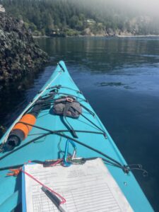
Bull Kelp Monitoring in Kayak by Marina Cousins
Maintaining accuracy while steering the kayak required continuous concentration, particularly when ferry wakes rolled through the area and currents shifted beneath. Active Pass is one of the busiest marine corridors in the Southern Gulf Islands, with ferries and recreational vessels regularly travelling between Galiano and Mayne Island. Balancing careful navigation with precise data collection highlighted the level of skill and coordination required for this type of fieldwork.
I gained a greater appreciation for the importance of standardized monitoring. The information collected during these surveys contributes to long-term datasets that help marine biologists and conservation organizations understand how bull kelp populations are changing over time.
As ocean temperatures rise and marine heatwaves become more frequent, bull kelp has become an increasingly important indicator species for the health of nearshore ecosystems. Monitoring allows researchers to identify areas where kelp forests are thriving, declining, or recovering, providing valuable information for future conservation and restoration efforts.
By the end of the survey, we regrouped to compare our findings before carrying the kayaks up the steep staircase. Although physically demanding, it was an incredibly rewarding morning experience that introduced me not only to the technical aspects of bull kelp monitoring but also to the dedication, teamwork, and careful planning that make these surveys possible.
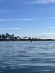
Amelia Kayaking at Cain Beach by Marina Cousins
Watching experienced volunteers and conservation staff work together demonstrated how community plays an essential role in protecting local marine ecosystems. Participating in this monitoring survey gave me firsthand appreciation for the value of collecting accurate field data and the commitment of organizations like the Mayne Island and Galiano Island Conservancies, that dedicate countless hours to understanding and protecting these remarkable underwater forests.
Additional bull kelp mapping surveys are planned throughout August as part of this ongoing monitoring program. These upcoming surveys will continue documenting the condition of bull kelp throughout the Southern Gulf Islands, contributing valuable information to long-term monitoring efforts and helping improve our understanding of these vital coastal ecosystems.
If you or anyone you know wish to take part as a volunteer in one of these surveys in the future, please contact Millie Kuyer, GCA Conservation coordinator, at millie.kuyer@galianoconservancy.ca.